The defences of the Odrin fortress
|
The entire
defensive system was divided into four sectors: a)
North-western Sector from the right bank of the Tundzha to the left of the
Maritza; b) Western Sector
from the left bank of the Arda to the right of the
Maritza; c) Southern
Sector from the right bank of the Maritza to the right of the Arda; d)
North-eastern Sector from the left bank of the Tundzha to the left of the
Maritza. In spite of
its faults, the North-western Sector was the strongest. Its resistance hung
firstly on the grounds conformation, then on correctly designed infantry and
artillery positions, in concrete casemates and in a well developed road
system. The Western and Southern Sectors had only field fortifications
because their defensive power lain in the position itself. The North-eastern
Sector proved to be the weakest, in spite of the favourable ground
conformation. Its technical main lack depended on
the absence of shrapnel-proof shelters for the sharpshooters and the
incorrect setting of the barbed wire entanglements. The North-western Sector ( As a whole the defences of this Sector, even if tactically perfect,
were not satisfactorily fortified. In 1912 the still unfinished strongpoints could be regarded only as simple field
works, because they had no gorges, covered ditch walls, flanking ditches and
only rarely had shelters for the sharpshooters in the breastworks. Due to the peculiar kind
of ground, to the shortness of the fire front and to the small, unprotected
ramparts, the garrison was not protected from the enemy
gun-fire. There were lacks also in the permanent
batteries: their casemates were not shell-proof and they could not bear up to
their own fire. On the other hand the interval infantry positions and the shelters for the reserve behind the girdle were effective and
the communications were flawless. The Northern Section, lain
on the height of Karagöz Tarla,
was composed by two lunette redoubts, interval infantry positions and nine batteries, four of them equipped with 120mm and 150mm guns.
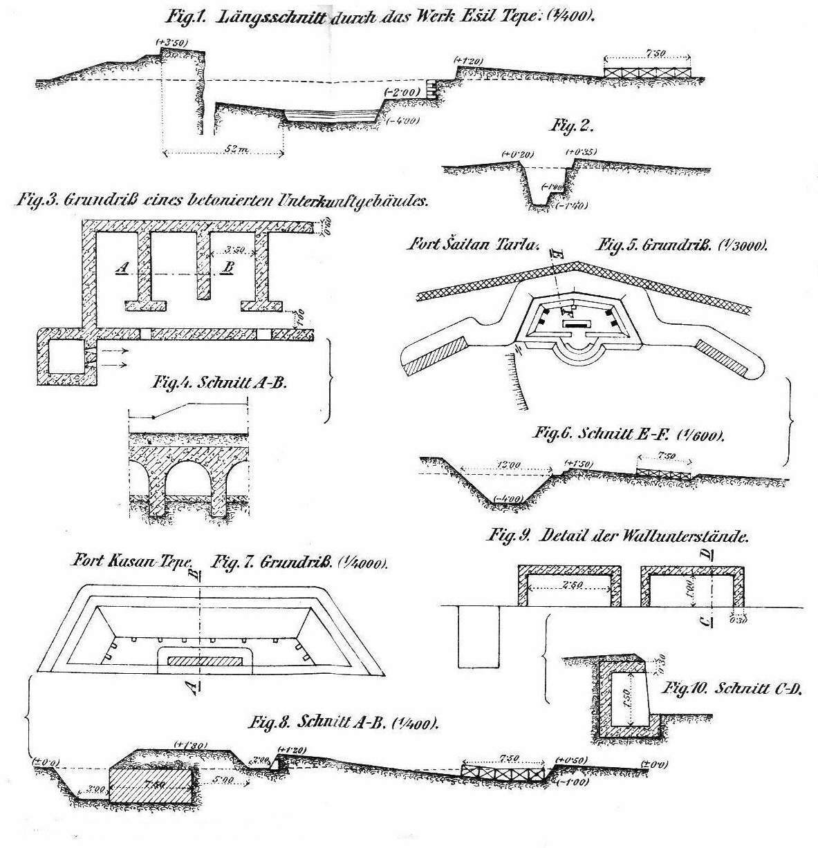
The two redoubts were called Ešil Tepel (I) and Jasž Tepe (II) [fig. 1]. They were
unfinished and visible from afar due to the light colouring of the
breastworks (yellow earth). On the other end the infantry positions [fig. 2] were slightly
visible and had a considerable resistance. At approximately 40m from the redoubts there were barbed wire
entanglements with a width of 10- The group Karagöz Tarla
had an advanced work on the heights of Juči Tepeler. It was a sort of lunette, built to prevent the enemy
artillery to occupy the crest, where it could carry out enfilade fire against the works of the Western Section. It was placed
on a wide hill, The Western Section granted an
unrestricted overview over the attack field and contained the works of Šaitan Tarla (III), Kazan Tepe (IV), Kazan Küprü (V), 27
batteries and the interval infantry positions. Šaitan Tarla, named also Karagöz Tabia [fig. 5 and 6], was an old
redoubt with gorges, high breastworks, casemated hollow traverses, a covered
way and defensive earth slopes. The barbed wire
entanglements did not surround the gorges. Two shelters were attached at the height
of the farthest and wing gorges similar to them depicted in fig. 3 and 4. Kazan Tepe, which was Behind the
forts some concrete shelters under the crest were protected from direct fire
by the ground itself and formed the waiting position. In front of the forts
many simpler trenches assured with the forts themselves a degrading fire
against enemy attacks. The lines of defence were connected by zigzag
communication trenches. The batteries
were placed hidden in the ground at 150 to 200m behind the infantry positions. Some of them had permanent emplacements and were armed with
150mm guns and 210mm mortars in central pivot carriage. Thanks to this mechanism and to the small girdle diameter these
batteries were able to support with their fire other threatened sectors of
the girdle. However the vaults of the casemates had a thickness of only 45cm, and
therefore they were not enabled to resist the 150mm shell of modern guns.
Moreover the construction itself was not faultless, since the vaults was
cracked by the vibrations of the guns own fire, so the
foundation sunk and gradually the wall entirely collapsed. In the
villages of Kadin köj and
Ekmekci köj, the Turks
had arranged advanced works and emplacements for the field artillery. Behind
the girdle the old works of Baš Yuk Tepe (VI), Kemer Tepe (VII) and Milet Tepe (VIII) with some field batteries formed a second
line of defence. They protected some great barracks and the Odrin main
arsenal, built at the end of the crest separating the Tundzha from its
tributary Kemer. In third line, the old The Western Sector ( The Southern Sector ( The girdle
comprised 4 works and 13 batteries. In the Marica
valley, the fort Bosna Tepe
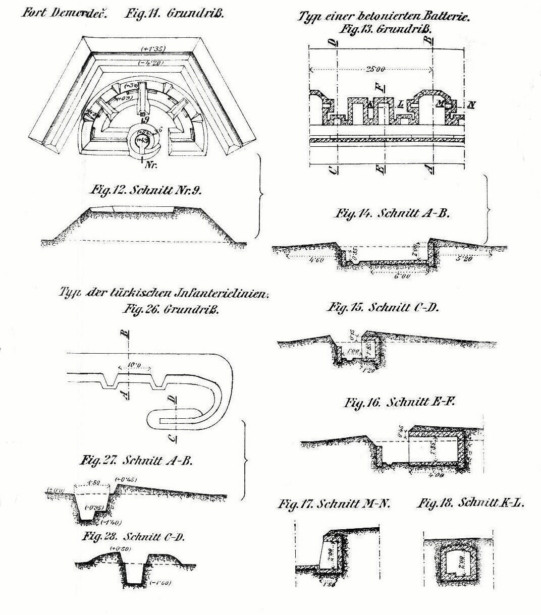
(X) lain in the village of Bosna köj, followed westward by Demerdeš
Tepe (XI) [fig. 11 and 12],
Karaăgac Tepe (XII) and Maras Tepe
(XIII), then, between Demerdeš and Karaăgac, near the
railway station, by the open work of Merkes Tabia (XIV). All these
forts were outdated and, in order to offer to the outskirts of Karaăgac with the railway station
a better protection against the enemy fire, Turkish Army decided to advance
the girdle further south and to build behind it some permanent batteries. At
the beginning of the hostilities the new batteries [fig. 13 to 18] lain in front of the old
forts. Infantry shelters connected with
barbed wire entanglements were built forward them.
From 5 to The North-eastern Sector ( In the North Eastern
Sectors the favourable ground conditions were wasted for the lack of the
necessary technical arrangements. The Turks tried to reduce this deficiency by the development of the advanced positions, achieving their goal only
imperfectly because they were not able to provide an adequate protection for
their troops and to separate the fore field positions from the main battle
line sharply. Near Maslak the two positions joined
up, so the enemy artillery could fire simultaneously to both. Only the
battery of the girdle could support the advanced positions, since an
incorrect arrangement of the barbed wire entanglements hindered the arrival
of the reinforcements and the withdrawal of the first line troops. The occupation of the advanced positions delayed somewhat the
bombardment of the city, but could not prevent the effects of the siege
artillery fire. Probably it would be better to use the old forts only as
observation posts and to shift the key of the defence to a more carefully
arranged advanced line. The Northern
Section extended from Tundzha to the The Eastern Section began near the fort
of Aivas Baba and extended to the Maritza. The main position lay on the crest, which ran almost in north-south direction, then approached the city up to All these forts were completely outdated: during their reconstruction
in 1885 they received only brick casemates with covers The batteries were placed in line in the intervals. Excepting few
exceptions they were badly masked and owing to the wide dead angles they were
not much fit for the direct fire. The majority of the heavy cannons was mounted on coastal carriages.
The field positions for the artillery had shrapnel-proof covers of
corrugated iron or wood and a wooden ammunition store. There were common
shelters for groups of batteries and for
the artillery duty of the whole Section a shelter The short
distance of this part of the girdle from the city and the care for the water
pipe pushed the Turks to occupy and to secure advanced positions at 1 to At the
mobilization the Turks occupied some external positions at 2 – a)
in the North-western
Sector they started on the crest east of Kadin köj, turned before the mamelon south of Ekmekci köj, reached the advanced work of Juči
Tepeler and, following the crest along the right
bank of the Tundzha, ended near the river, north of
the village of Havaras; b)
in the North-eastern
Sector they started near the Tundzha, south of Havaras,
reached the advanced work of Maslak, turned south,
following the crest east of the girdle, crossed Mal Tepe
and ended near the Maritza, behind the village of Bosna
köj; c)
in the Southern
Sector the positions were placed on the crest north of
the Pamuk dere and, going
on across the crests, reached the south bank of the Arda,
south the village of Čerek köj,
while advanced posts were established on the hill of Kartal
Tepe and before the village of Doudžaros; d)
in the Western Sector the positions were placed approximately These external
positions were composed by unbroken lines of trenches with shelters, where
the soldiers could usually fire on their foot, sometimes on their knees, but
without strongpoints. Behind the crests where the
combat positions were placed, the Turks built some shelters, with stoves and
pallets, where the troops stood during the winter 1912-13. The defence and
waiting lines were connected each other by covered ways and zigzag
communication trenches. There were
emplacements for machine guns and artillery, but usually the external
positions were armed only with field guns. There were only a few exceptions:
in the Western Sector the head of artillery, Nuri bey, placed some howitzers batteries in the advanced
posts, and in the Eastern Sector there were one 150mm howitzers battery at
Mal Tepe and one 120mm howitzers battery at Mezar Tepe. The line of defence
was somewhere protected by poor barbed wire entanglements. The communications were
generally sufficiently developed, especially in the North-western Sector, but
they proved insufficiently on the Eastern front. The place possessed a well
designed Decauville narrow-gauge railway ( The telegraph and telephone networks fully met needs. A wireless telegraph station was placed in |
|
|
|
Plans of the Turkish forts at Odrin |
